
GPS Entity Functions
Sep 28 2022 at 12:00 AM
- Distance
- From Latitude and Longitude
- Entity Entering Area
- Entity Leaving Area
- Entity In Area
- Previous Geo-location
- When Last In Area
- Drawing A Geo-fence
Distance
Function Description:
This function determines the distance (in meters) between two GPS-coordinates. These can be static or dynamic coordinates.
Function Structure:
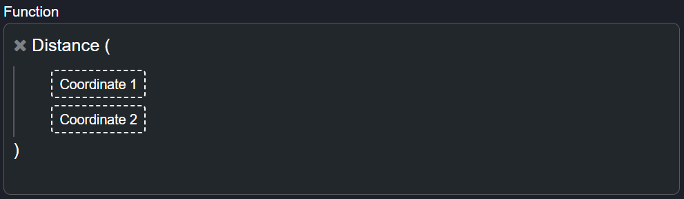
Figure 1 - Distance
Inputs Required:
- Coordinate 1 - (-32.933918, 21.44095)
- Coordinate 2 - (29.945519, 25.940276)
Outputs Expected:
- Return Distance - (71.51050)
Use Case Scenario(s):
1. This function can be used to calculate the distance that an endpoint has travelled, or the distance from its current location to a predetermined destination.
From Latitude and Longitude
Function Description:
When an endpoint sends the latitude and longitude of its location separately, you can use this function to combine the data. The GPS location function takes two parameters and returns the GPS location as a single result.
Function Structure:
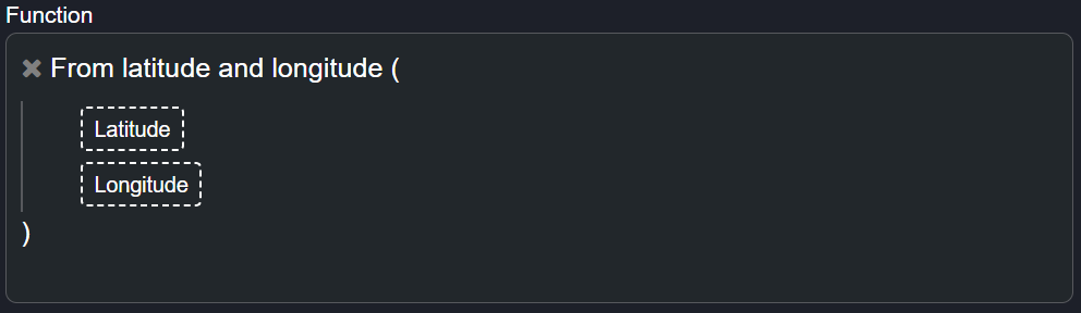
Figure 2 - From Latitude And Longitude
Inputs Required:
- Latitude - (-32.933918, 21.44095)
- Longitude - (29.945519, 25.940276)
Outputs Expected:
- Expected Result - GPS Coordinate (-25.895170, 28.160294)
Use Case Scenario(s):
This function is used display the GPS location of an endpoint by combining the latitude and longitude of an endpoint. It is used to pinpoint the location of an endpoint at any time througout its journey.
Entity Entering Area
Function Description:
This function determines whether an endpoint is entering a geofenced area. It takes the endpoint's current location as well as its previous location into consideration. If the current location is within the geofenced area, and the endpoint's previous location is not, the function returns true.
Function Structure:
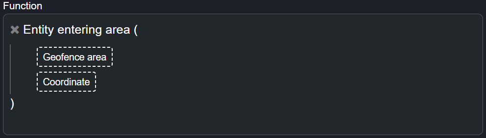
Figure 3 - Entity Entering Area
Inputs Required:
- Coordinate - (-32.933918, 21.44095)
- Geofence Area - Geofence 1
Outputs Expected:
- When entering geofenced area - True
Use Case Scenario(s):
1. This function can be used to monitor a moving asset and getting alerted when the asset moves into a particular or dangerous area.
Entity Leaving Area
Function Description:
This function determines whether an endpoint is leaving a geofenced area. It takes the endpoint's current location as well as its previous location into consideration. If the current location is outside of the geofenced area, and the endpoint's previous location was inside the geofenced area, the function returns true.
Function Structure:
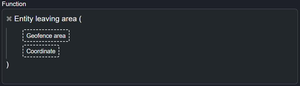
Figure 4 - Entity Leaving Area
Inputs Required:
- Coordinate - (-32.933918, 21.44095)
- Geofence Area - Geofence 1
Outputs Expected:
- When leaving geofenced area - True
Use Case Scenario(s):
1. This function can be used to monitor a moving asset and getting alerted when the asset leaves a predetermined area.
Entity In Area
Function Description:
This function determines whether an entity is within a geofenced area.
Function Structure:
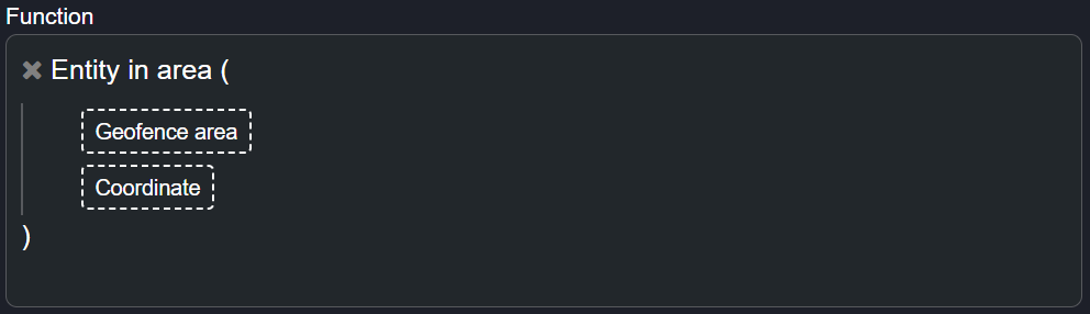
Figure 5 - Entity In Area
Inputs Required:
- Coordinate - (-32.933918, 21.44095)
- Geofence Area - Geofence 1
Outputs Expected:
- When and entity is inside geofenced area - True
Use Case Scenario(s):
This function can be used to monitor an entity and create an alert when the entity is not found in a predetermined area.
Previous Geo-location
Function Description:
This function returns the previous geo-location for an entity from a specified series of geofenced areas.
Function Structure:
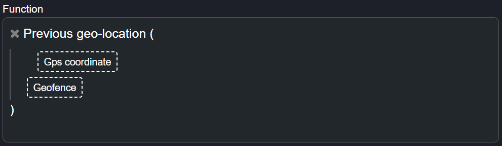
Figure 6 - Previous Geo-Location
When you add a geofence entity to the placeholder marked geofence, another placeholder will appear allowing you to add multiple geofenced areas to the function. |
Output 1: Enters geo-location 1.
- Endpoint DateTime - 2022/08/01 10:00:00.
- Previous-Geo-Location Result - NULL.
- Why - The entity is still in the geo-location, and therefore there is no previous geo-location.
Output 2: Leaves geo-location 1 and enters geo-location 2.
- Endpoint DateTime - 2022/08/01 10:15:42.
- Previous-Geo-Location Result - 2022/08/01 10:15, Entity Id of geo-location 1.
- Why - As soon as the entity exits geo-location 1, geo-location 1 becomes the previous geo-location.
Output 3: Leaves geo-location 2 and enters. geo-location 3.
- Endpoint DateTime - 2022/08/01 10:25:12.
- Previous-Geo-Location Result - 2022/08/01 10:25, Entity Id of geo-location 2.
- Why - As soon as the entity exits geo-location 3, geo-location 2 becomes the previous geo-location.
Output 4: Leaves geo-location 3 and enters geo-location 4.
- Endpoint DateTime - 2022/08/01 10:45:12.
- Previous-Geo-Location Result - 2022/08/01 10:45, Entity Id of geo-location 3.
- Why - As soon as the entity exits geo-location 4, geo-location 3 becomes the previous geo-location.
Use Case Scenario(s):
1. This function can be used to to keep a log of the areas the item being tracked, has visited.
When Last In Area
Function Description:
This function determines when a tracked entity was last within a specified Geofenced area. The function returns the date/time as well as a value of when the entity was last within the area.
Function Structure:
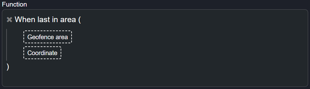
Figure 7 - When Last In Area
Output 1: Entity enters geo-location
- Endpoint DateTime - 2022/08/01 10:00:00.
- Previous-Geo-Location Result - NULL.
- Why - The entity is still in the geo-location and therefore there is no previous geo-location.
Output 2: Entity leaves geo-location 1 and enters geo-location 2
- Endpoint DateTime - 2022/08/01 10:05:02.
- Previous-Geo-Location Result - 2022/08/01 10:05, Entity Id of geo-location 1.
- Why - As soon as the entity exits geo-location 1, geo-location 1 becomes the previous geo-location.
Use Case Scenario(s):
1. This function can be used to determine when last an entity entered a specific geo-fenced area.
Drawing A Geo-fence
You can draw a geo-fence as a static endpoint from within the Commander™ Portal.
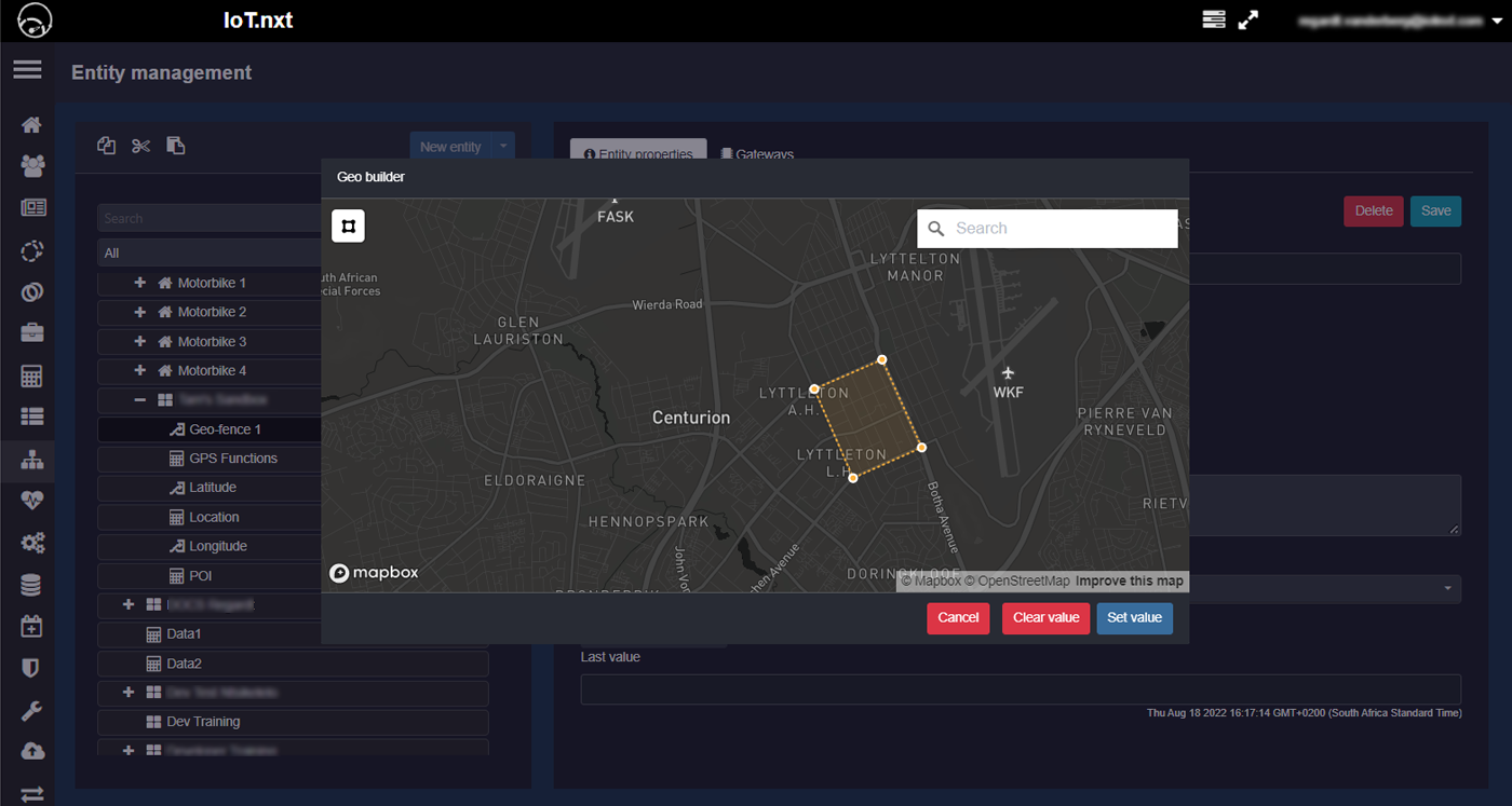
Figure 8 - Drawing A Geo-Fence
1. To create a geo-fence, click on the New entity button on the Entity Management page.
2. Name your geo-fence and select Geo polygonunder Data Type and click Launch geo-builder.
3. A new window will pop-up where you can browse the map to a desired location and click around an area to draw your geo-fence.